Right-Of-Way

PARTNERS. EVERY STEP OF THE WAY.
LOCATION
Montgomery County, Indiana
NUCOR ROAD NEW WASTEWATER TREATMENT PLANT & SANITARY SEWER COLLECTION SYSTEM
Survey/Right-of-Way Services
 Surveying.jpg)
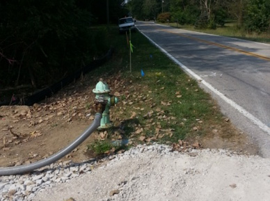
VS Engineering provided all design surveying services for a new wastewater treatment system near the Nucor Steel plant in Montgomery County, Indiana. The project included a new wastewater treatment plant, approximately 5.5 miles of sanitary sewers and over 2.5 miles of force main. To provide a "green" aspect to the project, effluent from the wastewater treatment plant will be pumped to the Nucor Steel recycling facility and reused for cooling purposes. VS gathered topography of the existing roadway and right-of-way for the design engineer and produced a Location Control Route Survey Plat depicting the roadway alignment, right-of-way and all adjacent properties. An ALTA/ASCM survey of the treatment plant site was also completed.
Project Tasks:
- Establish horizontal project control tied to a custom designed geodetic coordinate system implemented to reduce distortions between grid (mapped) and ground (true) distances
- Establish vertical project control tied to the North American Vertical Datum of 1988
- Locate or re-establish more than 20 United States Public Land Survey System (USPLSS) corners
- Obtain last deed of record for 130+ properties along project route
- Perform detailed right-of-way search to prove county ownership of existing right-of-way
- Obtain title searches, both insured and uninsured, for land acquisition
- Prepare seven easement descriptions and plats
- Cross-section existing pavement, ditches and ground every 100 feet
- Locate all existing topography features such as manholes, drainage structures, utilities, trees, etc.
To take full advantage of GPS technology VS utilized the INDOT InCORS Real-Time Network (RTN) to allow field crews to dial into the network using cell phone modems. Production rate of two VS on-site GPS receivers was more than doubled during this project. Use of the RTN also allowed for easier access to State Plane Coordinates and greatly reduced the time and effort needed to located remote USPLSS corners. Establishment of project control tied to the custom geodetic coordinate system allowed for seamless integration of IndianaMap orthophotos and inclusion of information obtained from the Montgomery County GIS database.

 Surveying_thumb.jpg)